Mapping Applications
The DEP maintains custom web applications for both DEP and the public. Some applications are designed as general exploratory tools organized around a particular type of data, often related to a particular permitting activity or DEP office. Other applications are designed to provide task-driven information quickly, without the need to start a desktop application or calculate an answer manually.
New
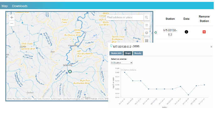 WAB sample database
 Visualize, query, and download data from the Watershed Assessment Branch Database, which includes over 2 million results sampled from over 15,000 locations throughout the state.
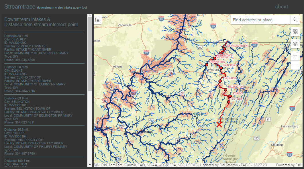 Stream trace
 Identify potentially affected public water sources downstream of a location by clicking on a map. This app has been redesigned to use stream network traversal to report all intakes found below a selected point and the approximate distance.
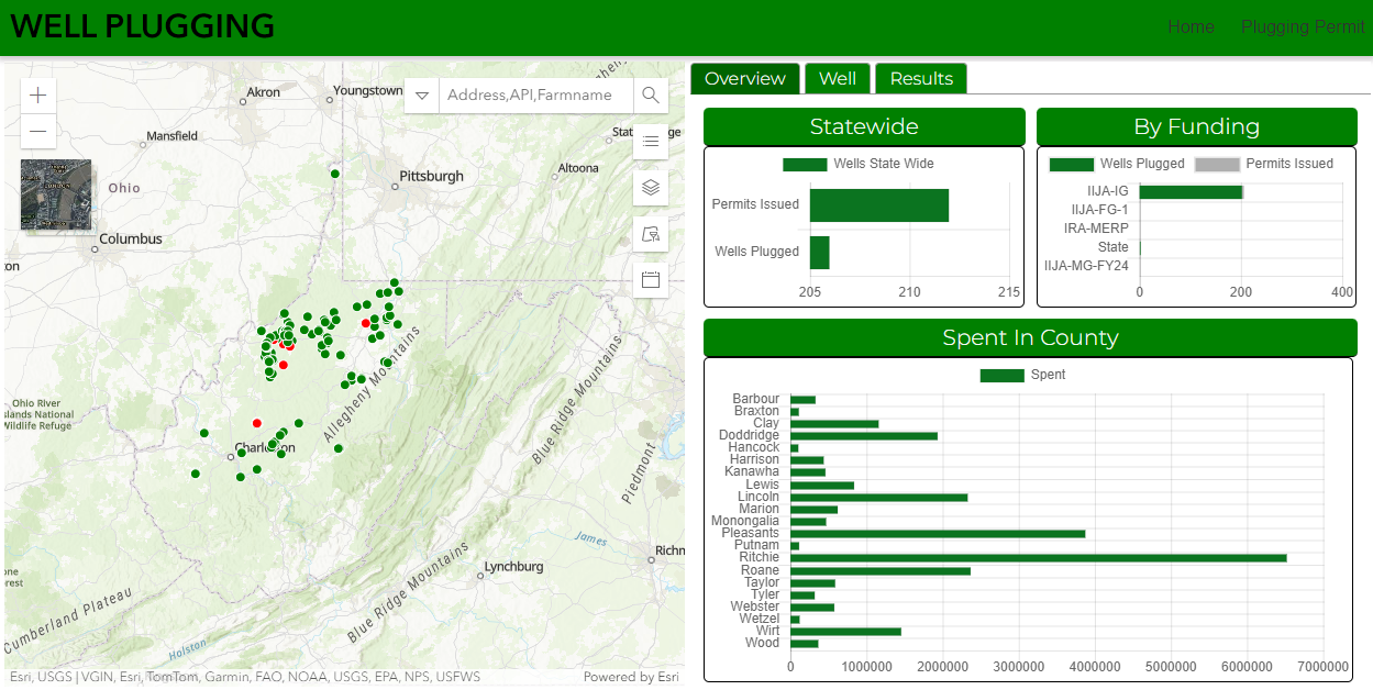 Well Plugging Activity
 Track recent oil&gas well plugging activity, locations, and funding sources via this custom dashboard application.
DEP Program Applications

A general purpose mapping application for viewing WVDEP enterprise GIS data from various program offices. The print function can be used to produced georeferenced pdf files that can be used with
avenza's pdf maps app on mobile devices in the field. The same map can be loaded in
Esri's explorer app on connected mobile devices by searching for 'wvdepmap' from within the app.

Division of Air Quality permit locations
 Data Browser--
 view, search, and identify mining data from WVDEP DMR, AML, and WVGES
 Trend station compare--
 compare results from two trend stations for a selected sample parameter. The trend station database contains water sample results from a set of fixed sampling locations dating back to 2003. Data is entered diretly from results submitted by the contracted laboratory. WVDEP does not conduct additional QA/QC review and data is provided as received.
 Trend parameter compare--
 compare results for two parameters for a single trendstation. See trend station database description above.
 Well data browser
 An application for exploring the locations of wells permitted by the Office of Oil and Gas. Provides multiple parameter search and displays graphs of reported oil and gas production.
Well Plugging Activity Track recent oil&gas well plugging activity, locations, and funding sources via this custom dashboard application.

An application that shows locations of illegal dump sites and associated cleanup projects managed by the Pollution Prevention and Open Dump Program.
WAB sample database Visualize, query, and download data from the Watershed Assessment Branch Database, which includes over 2 million results sampled from over 15,000 locations throughout the state.

Initially developed by the WVDEP Water Use Section. An application designed in response to the ater Resources Protection and Management Act of 2008 to provide access to information on Large Quantity water users as well as other GIS data layers pertinent to water resource management in the state of West Virginia.
A web application that shows WV landfill closure assistance program data and UAS imagery. run this application
Utility Applications

This application converts between Lon/Lat and UTM coordinates for the Unites States. It will also convert to/from State Plane coordinates for locations in West Virginia. Results are plotted on an interactive map. Alternately, users can click on the map and get coordinates for the clicked location. A list of conversions is maintained in comma-delimited format in a text window that can be copied and pasted to a spreadsheet or other program.

Display precipitation totals across the state for a given date range. Data from
NWS Nexrad 24-hour observed precipitation totals, downloaded daily and maintained in a local database. Originally designed to assist with investigation of drainage issues on mining sites.

A tool for comparing drone data products from different times and different sensors, including color, color infrared, red edge, thermal, NDVI, and hillshade during leaf-on and leaf-off conditions

Provides interactive access to data from the West Virginia Wetland Rapid Assessment Method (WVWRAM), which is a standardized protocol for rapidly assessing the functions, services, values, and condition of wetlands.

This application displays calculated flow estimates for streams in the state, based on equations in USGS publications. For more information on the analysis process used to calculate the flow estimates, see
here.
Note that this application relies on USGS publications from 2008-2010. The
USGS streamstats application is now available and provides a more comprehensive set of estimates.
Identify potentially affected public water sources downstream of a location by clicking on a map. This app has been redesigned to use stream network traversal to report all intakes found below a selected point and the approximate distance.

This application provides recommendations on whether it is advisable to make water withdraws from streams in the state, depending on real-time flow information from USGS stream gages. Note that this guidance tool is less strict than the water management plans for Oil and Gas Permits. Approved water management plans include safety margins to account for uncertainties related to ungaged streams.

Shows locations of facilities reporting chemical releases to the air, land, and water reported to the Toxics Release Inventory since 1987. A version of this application has been continuously available since the original was published as a Java applet in 1997. Updated to Esri JavaScript 4.24 in 2022.

A utility application that displays locations of geotagged jpeg images, as well as GPX files
 Karst Feature explorer