GIS Data
The WVDEP provides downloads for GIS data developed or maintained by the agency, either from this page or the Open Data Hub
Note that shapefile attribute fields may be truncated due to a 10 character limit on field widths.
In addition to commercial GIS software, QGIS is open source software that can read file geodatabases. ArcGIS Earth is recommended for viewing shapefiles.
The GIS server has been experiencing intermittent problems downloading files larger than 3Mb. If you are having difficulty downloading vector data, try using this google drive link instead: https://drive.google.com/drive/folders/1DRx_z9RZctJqkXgTRzS7_yW_HQFg8D5l
Vector data
 |
Abandoned Mine Lands |
| all layers (gdb) | |
| problem areas (shp) | Organizational units of AML problems used to plan reclamation projects |
| problem area labels (shp) | Cartographic labels of AML problem areas |
| polygon features (shp) | Area features related to pre-1977 mining, see AMLIS problem types for details on feature types. |
| point features (shp) | Point features related to pre-1977 mining, see AMLIS problem types for details on feature types. |
| line features (shp) | Linear features related to pre-1977 mining, see AMLIS problem types for details on feature types. |
 |
Air Quality |
| all layers (gdb) | |
| facilities (shp) |
 |
Environmental Remediation |
| all layers (gdb) | |
| open dump (shp) | Open dumps identified by the Pollution Prevention and Open Dump Program. Includes pending and completed projects. |
| vol. remediation sites (shp) | Locations of voluntary remediation sites maintained in the WVDEP ERIS database |
| Additional data: | |
| Land Use Covenants (KMZ) | Polygons identifying areas subject to land use restrictions due to prior contamination. Note these boundaries are approximate. |
 |
Mining & Reclamation |
| all layers (gdb) | |
| mining limits (shp) | Proposed extent of underground mining. Used for subsidence contol plans. This is not an indicator of actual mine workings, but can indicate where future underground mining may occur. additional info |
| mining npdes outlets (shp) | locations of outlets for NPDES permits associated with mining activity. |
| permit locations (shp) | point coordinates of permits, extracted from the permit tracking database. Includes approximate locations of many older permits that have no available map, and prospecting permits. |
| permit boundary (shp) | extent of the bonded area within which mining activity is permitted to occur. additional info |
| active blasting (shp) | subset of the permit boundary layer that includes permits indicated in the permit tracking database to have blasting activity in the last 30 days |
| refuse structures (shp) | structures used for refuse disposal from coal processing, including impoundments. |
| spoil fills (shp) | Overburden spoil fills additional info |
| spoil fill terminal pnt (shp) | Approximate downstream termination points of overburden fills, extracted from the permit tracking database. This data was entered from permit applications, and is less inclusive than the polygon features that were derived from remote sensing and map sources. |
 |
Oil & Gas |
| all layers (gdb) | |
| laterals (shp) | Simplified 2-point or 3-point directional laterals for horizontal wells, when available. additional info |
| permits (shp) | permits and associated coordinates, extracted from the permit tracking database. Because multiple permits can be issued over the operational life of a single well, multiple point features can overlap at the same location. |
| wells (shp) | well locations, extracted from the permit tracking database additional info |
 |
Special Reclamation |
| all layers (gdb) | |
| special reclamation boundaries (shp) | boundaries of post-SMCRA forfeited permits associated with the special reclamation program. Permits that do not have an available boundary map are represented as circular features centered on a point coordinate, sized to to the permitted acrage, when available. |
| special reclamation sites (shp) | |
| waterbf sample data (shp) |
 |
Watershed Assessment |
| all layers (gdb) | |
| wabbase sample info (shp) | |
| wabbase stations (shp) | |
| Additional data: | |
| 2016 303d streams (shp) | Available from the West Virginia Integrated Water Quality and Monitoring Report page |
| Tier 3 streams (shp) | Available from the Water Quality Standards Page |
 |
Water Resources |
| all layers (gdb) | |
| npdes outlets (shp) | |
| npdes permits (shp) |
West Virgina karst sink data
karst depressions extracted from 1m lidar elevation grids for two regions of West Virgina
- web map
- Eastern panhandle project report
- Eastern panhandle data download (gdb)
Jefferson-Berkeley Counties
Greenbrier, Pocahontas and Monroe Counties
LiDAR data
WVDEP Lidar data was collected by the Natural Resource Analysis Center at WVU under contract with the West Virginia Department of Environmental Protection, Division of Mining and Reclamation.
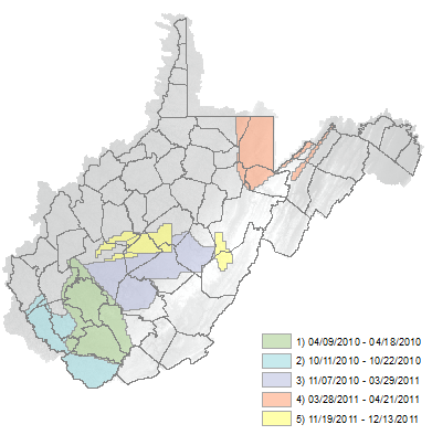
The data was collected between 04/09/2010 and 12/13/2011 during leaf-off, snow and flood free conditions in the spring and fall. This is now an historical elevation data source. More current lidar is now available through the USGS 3DEP program.
The data format is 1.5x1.5 km LAS v1.2 files in UTM 17 NAD83 (CORS96), NAVD88 (GEOID09). Contractor software initially classified ground returns for comprehensive and bare earth tiles, but did not perform other classifications. The Technical Applications and GIS (TAGIS) unit at the WVDEP performed Quality control checking and error correction on a tile-by-tile basis before creating derived products and edited LAS files.
Individual LAS format tiles are available for download directly from an interactive map. Tiles are 1.5km square. Using the application is easy-- just zoom in until the 1.5km tile grid is visible and click on a tile. A popup window will contain a link to the tile. Tiles also can be downloaded directly from the lidar repository
Hardware and flight parameters:
Scanner: Optech ALTM-3100
Post Spacing (Average): 3.3 ft / 1.0 meter
Flying Height (Above Ground Level): 5,000-ft / 1,524 meters
Average Ground Speed: 135 knots (155 MPH)
Scanner Pulse Rate Frequency: 70,000 Hz
Scanner Frequency / Field of View: 35 Hz / 36 degrees (18 half angle)
Overlap (Average): 30%
Lidar Documents & shapefiles:
-- dataset boundaries for lidar datasets in West Virginia-- tile boundaries for lidar datasets in West Virginia (shp)
-- tile boundaries for WVDEP lidar datasets in West Virginia (downloadable from this site)
-- metadata overview
-- deliverable_1_RAMPP_quality_assessment.pdf
-- deliverable_2_metadata.xml
-- deliverable_2_Project_Report.pdf
-- deliverable_2_RAMPP_quality_assessment.pdf
-- deliverable_2_Survey_Control_OPUS_reports.zip
-- deliverable_3_metadata.txt
-- deliverable_3_RAMPP_quality_assessment.pdf
-- deliverable_4_metadata.xml
-- deliverable_4_Project_Report.pdf
-- deliverable_5_Elk_ProjectReport.pdf
-- deliverable_5_metadata_Elk.xml
-- deliverable_5_Output_Control_Report_TugNotch.txt
-- deliverable_5_TugNotch_metadata.xml
-- deliverable_5_TugNotch_ProjectReport.docx
-- deliverable_5_TugNotch_ProjectReport.pdf
